


Yuraygir National Park has multiple points to access the park and they are not all accessible to each other. This brown sign destination is for the section of Yuraygir National Park accessed near Brooms Head ![]()
![]() , using the exit at Maclean.
, using the exit at Maclean.
Yuraygir National Park is between Yamba and Corindi (north of Coffs Harbour). With 65km of coastline it is the largest coastal National Park in New South Wales. It was created in 1980 by combining the Angourie National Park and Red Rock National Park.
Accessing Yuraygir National Park via Brooms Head actually takes you to two parts. The first is the cheaper location with a set of camping spots just a few kilometres before reaching Brooms Head. The second has better amenities and accessed from a dirt road turning off a little closer to Brooms Head to go to the Sandon campgrounds next to the Sandon River.
Both locations require a vehicle pass, whether you are camping or just visiting for the day.
Brooms Head Camping Areas
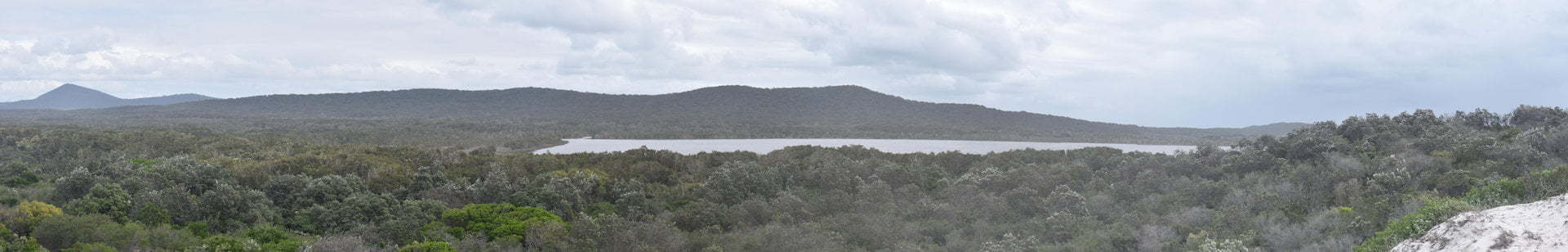
The Brooms Head camping areas are on a loop track with Lake Arragan, Red Cliff, and Grey Cliff camping areas. The directions and map location for this brown sign takes you to the Lake Arragan camping area at the north end of the loop.
Lake Arragan camping area is a short sandy track from the outlet of Lake Arragan and onto the beach. A shorter path leads to a boat ramp where you can launch a paddle watercraft.
The main part of the lake is a few kilometres walk along the Yuraygir Coastal Walk, which leads through to Mara Creek Picnic Area and Angourie Bay Picnic Area in the Angourie section of Yuraygir National Park ![]()
![]() .
.
To access the walk you will need to cross the outlet which could be under water during higher tides. We timed it well enough to have lower tides and this was not a problem.
We walked as far as Plumbago Head but if we had more time we could have continued through to Shelley Beach, We walked to Shelley Beach from Mara Creek Picnic Area earlier. Walking it in sections and returning eliminates the need for arranging transport as the one-way walks are quite lengthy. The 10 kilometre walk to Mara Creek Picnic Area is about 5-6 hours one-way, but from the campground to Shelley Beach is less time return.
If you have the gear, you can take your swag and stay overnight at the Shelley Headland Walk-in camping area. Either way, make sure you take plenty of water as there is basically nothing along the walk.
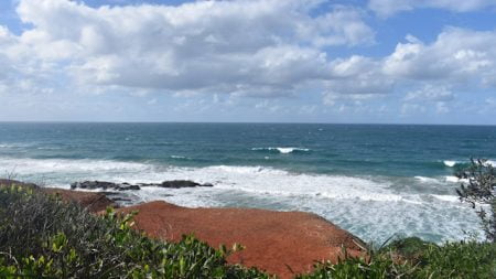
From Plumbago Head we could see glimpses of the main part of Lake Arragan. Had the weather been brighter we may have continued on but we decided to head back.
At the lake outlet, the boys discovered a few cuttlefish, finding ever larger examples. They were huge, sizes I have never seen before. They were fascinated by this so much it alone made it worthwhile visiting for them.
We saw numerous emu tracks on the walk and in the sand on the beach. As we walked along the trail we saw a few more tracks but we didn’t come across any emus in person.
The campground has long-drop toilets and nice grassy areas to set up on. The only water is for handwashing at the toilets and was a dribble at best, so no water generally available.
The Red Cliff camping area is set near the red cliffs along the coast line. Clearly, the Red Cliff camping area gets its name from the colour of the red cliffs. It is the same reason Redcliffe got its name where we are based, so it was interesting to find the same name elsewhere.
Red Cliff camping area has smaller more secluded camp sites with a short walk through the coastal scrub to reach the cliffs.
Grey Cliff camping area is more exposed than the other camping areas, essentially open to the cliffs with no trees to break the wind coming in from the coast. It also has long-drop toilets and bins are around for rubbish.
Sandon River Camping Area
The Sandon River camping area is further south on a peninsular next to the mouth of the Sandon River, accessed along the unsealed Sandon River Road.
The campground at Sandon has better facilities compared to Lake Arragan and Red Cliff, although it is more remote with the nearest basic supplies at the Brooms Head town. Sandon village is on the other side of the river, requiring a boat or other watercraft to get across to.
The facilities include free BBQs and sheltered picnic table areas and a boat ramp to launch your boat to head out for a bit of fishing.
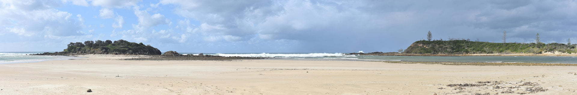
At the end of the peninsular is Plover Island, a registered Aboriginal site where Yaegl people quarried stone used to manufacture and maintain wooden weapons and implements. Grinding grooves in the flat rocks and quarry faces show signs of tools being made.
The Yuraygir Coastal Walk reaches the Sandon River where a boat is required to continue further south. Without water vessel assistance, the walk heads north towards Brooms Head and the Lake Arragan campgrounds, an 8 kilometre walk one-way taking about 3.5 hours. This section could be done as a return walk with preparation and plenty of water to take with you.
Transport is needed to be arranged for a one-way work between Brooms Head and Sandon River, as well as getting to Sandon Village across the river if you can’t cross by boat.
The beach to the north of the Sandon camping grounds is open for 4wd access. There is about 6 kilometres of beach that can be driven on until it reaches some rocks. There appears to have been an access track at the north end at some time but no longer used.
The beach is quite firm with a few soft spots here and there. We were driving during a lower tide so it could be harder driving during high tide as it often is when beach driving. The entry has a steep dropdown onto the sand which may cause problems for soft roaders or those thinking about taking a more conventional vehicle onto the sand.
Sandon River is a nice campground with beach access practically at your front doorstep. While we didn’t stay there overnight, it certainly is a place we would spend some time to relax and enjoy the area more.
Bosches Waterhole
After Brooms Head we were headed for Wooli section of Yuraygir National Park. Bosches Waterhole Road is a 4WD only track that takes you from Sandon River Road to Candole Forest Rd, which heads south through Candole Forest to Wooli Road.
We could have headed back out to the Pacific Hwy and come back in towards Wooli from there, however, we took the more scenic and interesting way. It is a shortcut in distance but possibly took longer than heading out to the highway.
The track is mostly easy and was done in high range the whole way. It started to rain for a short while which made a few bits a little greasy but wasn’t challenging. More rain could have made it more difficult.
The first part is driving up Bosches Waterhole Road, which is about 3 kilometres from Brooms Head Road along Sandon River Road. About 2.5km along Bosches Waterhole Road is a long water section. The water was fairly shallow and has a stony base, easy to get through with a standard 4wd.
This section appears it would have water all the time, considering it was generally quite dry when we were there, it had plenty of water in it. Perhaps during wetter times it could get deeper, however, it appears to be a fairly constant level looking at the trees and land around it.
There are parts along the way you could get stuck if you “have a go”. In keeping the tracks in good order, and even more-so travelling as a single vehicle, we made sure to stick to firm ground and avoided unnecessary mud holes.
Bosches Waterhole Road starts to climb up the range towards Condale Forest Road. It was giving us some hope to see a view through to the coast once we were higher. Unfortunately, there wasn’t any clear views we saw and glimpses we did see through the trees were faded out by the badly timed weather bring down the rain.
Following Bosches Waterhole Road was straight forward, coming out onto Condale Forest Road. Condale Forest Road was a little trickier with signage completely missing from some intersections. There was a t-intersection in particular that left us wondering whether to turn left or right. Left was the correct way to go and had us out to Wooli Road soon enough.
There are some parts that are moderately steep but never had anything steep enough to require low range. There is possibly more challenging tracks through the area and it would be interesting to do some more exploring another day. As an alternative route to get between Brooms Head and Wooli with something different to more kilometres on the highway, it is a worthwhile track to take.


