


The HMAS Gayundah was a gunboat with the Royal Australian Navy, originally serving with the Queensland Maritime Defence Force as the HMQS Gayundah before the Federation of Australia.
Built during 1884 at Newcastle upon Tyne in the United Kingdom, it left for Australia late in 1884 via the Suez, finally arriving in Brisbane in March 1885.
Gayundah was a steam powered twin screw vessel, carried up to 75 tonnes of coal with a range of up to 1,300 kilometres.
Gayundah holds the honour of a couple of firsts. In 1886 it was granted privilege or wearing the White Ensign and Pendant of her Majesty’s fleet, a first for any colonial ship. It was also the first warship in Australia to successfully operate wireless telegraphy.
After its military service, including acting as a guardship and patrol vessel during World War I, Gayundah was sold in 1921 and used as a sand and gravel barge on the Brisbane River.
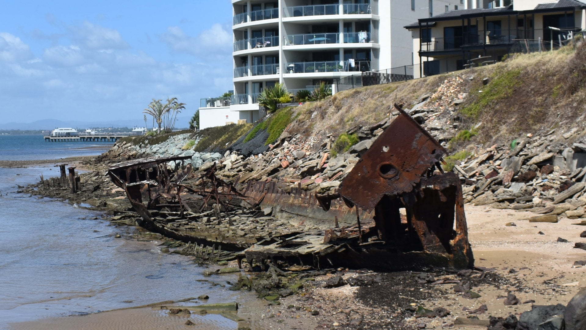
In 1958, the Gayundah was bought by the Redcliffe Town Council and beached to become a breakwater for the Woody Point cliffs, where the remains of it sits now.

Large parts of Gayundah were scrapped before being beached, however, it has deteriorated further after more than 60 years. It is only in the last few years the top part of the bow has broken from the hull, sitting precariously on the rest of the bow.
There have been bids to preserve or slow down the rusting away of the wreck, but nothing has been done that I’m aware of.
There are two main spots to look at the wreck from. The brown sign leads to a spot above the wreck along Gayundah Esplanade, giving the highest viewpoint at the wreck unless you are in one of the highrise apartments above it.
From here there is a path leading down into the park of Gayundah Coastal Arboretum ![]()
![]() which has a path leading back to the Gayundah wreck below the cliffs.
which has a path leading back to the Gayundah wreck below the cliffs.
Climbing on the wreck is prohibited with signs warning of penalties of doing so. It appears the signs used to mention going near the wreck is prohibited also but this part has been covered. Coming from the other side of the cliffs scrambling over the rocks during low tide doesn’t have the same warning signs, but with the deterioration of the wreck it is wise to stay a distance away from it all the same.
To get there:

Coming from north of Brisbane along the Bruce Hwy, follow the signs to Redcliffe. A brown sign to Redcliffe is at the approach to Deception Bay Rd (exit 142). Follow Deception Bay Rd for 7.7km, and turn left into Anzac Ave. Continue straight following Anzac Ave for another 6.6km, turning right onto Oxley Ave towards Margate. Follow Oxley Ave for 3.5km staying in the left lane towards the end towards Woody Point. Turn left at the roundabout into Lilla St and follow through to the next roundabout. Head straight through the roundabout with the brown sign for Gayundah Wreck. The view from the road is 50m on the right.
Coming from the south, there are two points to enter Redcliffe. The Deagon Deviation is accessed from the Gateway Motorway (exit 120A). Follow the Deagon Deviation for 6.1km, and cross over the Ted Smout Memorial Bridge, another 2.9km. At the end of the bridge, follow to the right from the 2 right lanes off the bridge onto Hornibrook Esp. Continue for along Hornibrook Esp for 2.4km, and turn right towards the Tourist Drive and Woody Point. At the end, turn right onto Oxley Ave, then immediately left into Lilla St at the roundabout. Follow Lilla St to the next roundabout and heat straight through with the brown sign for Gayundah Wreck. The view from the road is 50m on the right. (NOTE: The Deagon Deviation is no longer accessed from the two right-hand lanes. This has changed and Exit 120A from the left lane is now used).
Coming from the south, you can also head up the Bruce Hwy from along Gympie Rd. If you miss the Deagon Deviation exit, you will eventually come to this exit also. Take the exit to Anzac Ave (exit 133), and keep to the right lane to go under the overpass and loop back to Anzac Ave, turning left towards Redcliffe. Drive for 4.8kms and turn right to continue along Anzac Ave. Continue straight following Anzac Ave for another 6.6km, turning right onto Oxley Ave towards Margate. Follow Oxley Ave for 3.5km staying in the left lane towards the end towards Woody Point. Turn left at the roundabout into Lilla St and follow through to the next roundabout. Head straight through the roundabout with the brown sign for Gayundah Wreck. The view from the road is 50m on the right.
Cost: Free
Hours: Anytime
Toilets: No
Bins: No
Tables: No
Seating: No
Water: No
Food: No
Wheelchair accessible: Yes, assistance may be required to see the wreck
Pets: Yes, on leash
BBQ: Yes
Playground: No

