


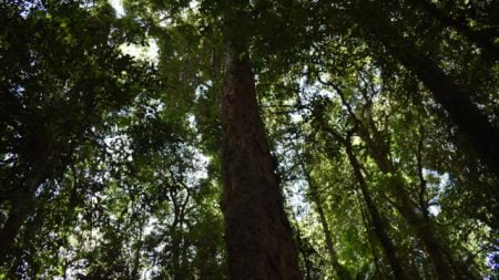
Brindle Creek is a small picnic area in the Border Ranges with walks along Brindle Creek and the Red Cedar Walk.
The picnic area is well shaded by the lush rainforest, the picnic tables nestled in the forest are as damp as the rest of the rainforest ground.
With so many places to consume time in the Border Ranges, time for lunch may occur at any of them. There are other spots where a picnic lunch would be easier but it will serve well enough if the time is right.
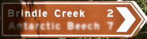
The main reason to come here though is the walking tracks along the banks of Brindle Creek, with two loops starting at the picnic area, and a longer walk through to Antarctic Beech Picnic Area  .
.
Brindle Creek Walking Track
The main walking track follows Brindle Creek upstream, starting from the picnic area and the first part of the Helmholtzia Loop Walk.
The grade 3 walk is 6km one-way, so make sure you allow plenty of time if you are walking return, about 3-4 hours one way.
Stopping at Evans Falls with a swimming hole below it is a good spot for a swim to cool off. Beware, however, the water is very cold even during the summer months. Selva Falls is further upstream with the beautiful, crisp water cascading over boulders.
Helmholtzia Loop Walking Track
Helmholtzia is a short easy grade walk along the banks on one side of Brindle Creek and returning along the other side, taking about 35 minutes.
The name of the track comes from the helmholtzia plant, also known as the stream lily, only found in the rainforests of north-east NSW and south-east Queensland.
The walk starts along the same track as the Brindle Creek Walking Track before splitting and crossing over the creek along a narrow board bridge, returning along the opposite banks of the creek.
The walk comes out on the other side of the vehicle bridge, which is walked on to return to the picnic area.
Red Cedar Loop
Red Cedar Loop is a short 750m walk heads downstream of Brindle Creek from the picnic area, leading to a giant red cedar tree.
The tree is 48 metres tall and a diameter of 133 centimetres, estimated to be around a thousand years old. Cedars are one of the few Australian trees to lose their leaves in winter, producing bright copper red leaves in spring.
Red Cedar Loop starts and finishes at the same spot, back along the road a short way from the picnic area, the loop starting part way in.
To get there
From Kyogle or Murwillumbah, see the directions for Border Ranges National Park to get to Bar Mountain Picnic Area, or see directions for Sheepstation Creek Campgrounds ![]()
![]() to come from the other end, including from Kyogle.
to come from the other end, including from Kyogle.
From Bar Mountain Picnic Area, turn left to head north on Tweed Range Scenic Dr and follow for about 18.5km. Turn right into Brindle Creek Rd at the brown sign for Brindle Creek. Continue for about 1.8km with the Brindle Creek Picnic Area just before crossing over the bridge.
From Sheepstation Creek Campgrounds, head out of the campgrounds and turn left onto Forest Rd which becomes Tweed Range Scenic

