

Flinders Plum Picnic Area is within the Flinders-Goolman Conservation Estate. It lies along Sandy Creek, between Mt Blaine and Flinders Peak.
There are a couple of moderate walks, along Sandy Creek and part way along the walk up Flinders Peak. For those who want a difficult walk, then the full walk up to Flinders Peak is for you.
Flinders Plum Picnic Area is joined to Hardings Paddock Picnic Area ![]()
![]() , via the Flinders Goolman Trail. The 19km trail starts at Hardings Paddock Picnic Area, and continues passed Flinders Plum Picnic Area through along Sandy Creek and continues south.
, via the Flinders Goolman Trail. The 19km trail starts at Hardings Paddock Picnic Area, and continues passed Flinders Plum Picnic Area through along Sandy Creek and continues south.
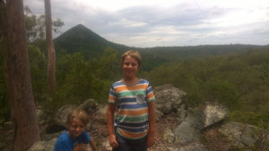
 We walked up part of the Flinders Peak Hiking Track, rated as Difficult, stopping before reaching the first peak. The track starts off quite easy, the first part being a well formed track where you can get a quick view across to Mt Blaine. Continuing upwards follows a vehicle track (no, you can’t drive it), which takes you a fair way until it reaches the first steep section.
The trail becomes a narrow single file track, and there are no steps or formed paths. There were some sections we needed to ask for assistance from nearby trees to scrabble up some steep obstacles, and I needed to help my boys in a couple of spots that were too steep, and trees out of their reach.
 We went as far as reaching a rocky section with the first peak in sight. It was a hot day, even if a bit overcast, and the track was getting harder. We hadn’t reached what is known as the chimney, which I wouldn’t have gone up with the kids.
Stopping at this point was not without rewards however, the views from this point were great, looking back towards Mt Blaine. No doubt the views are more stunning from the first and second peaks.
To get there:
 From Peak Crossing, head north towards Ipswich on Ipswich Boonah Rd for 2.2km, and turn into Mount Flinders Rd with the brown sign to Flinders Plum Picnic Area. After 3km, Mount Flinders Rd will become a grave road. 3.3km further on is a sharp left bend, do not use the track straight ahead. The entrance over a cattle grid is 1.2km further on from the bend, and the parking area is a little further ahead.
From Ipswich, head south along Ipswich Boonah Rd. From Cunningham Hwy continue for 11.5km, and turn into Mount Flinders Rd with the brown sign to Flinders Plum Picnic Area. After 3km, Mount Flinders Rd will become a grave road. 3.3km further on is a sharp left bend, do not use the track straight ahead. The entrance over a cattle grid is 1.2km further on from the bend, and the parking area is a little further ahead.
Cost: Free
Hours: Mon-Sun 6am-6pm
Toilets: Yes
Bins: Yes
Tables: Yes
Seating: Yes
Water: Yes, not potable
Food: No
Wheelchair accessible: Yes, at picnic area only
Pets: No, except horses
Playground: No
BBQ: Yes

