


Bribie Island is the most accessible of three islands protecting the Moreton Bay area, connected to the mainland by a bridge. The Ocean Beach on the eastern side of the island stretches for over 30 kilometres, accessible only by 4WD.
Bribie Island National Park is a playground of many types, from four-wheel driving along the beach and the inland tracks, to checking out the historical defence structures from World War II, swimming in the lagoons or the ocean, beach fishing, setting up a spot to sit back and enjoy the onshore breeze watching the world go by while scrapping sand with bare feet.
You must have a vehicle permit to drive on the ocean beach at Bribie Island or the inland tracks in the Bribie Island National Park area.
The permit to go out for the day requires a one week permit or an annual permit. The one week permit is around $50 so it makes it an expensive trip, one of the most expensive vehicle permits. Heading out more than 1 day makes it a little more reasonable, such as head out Sunday and go again on Saturday the following weekend. Better value can be had with an annual permit at around $150, providing you actually use it. I have had an annual permit a few times and have managed to get on the island four or more times in the year.
If you don’t have a 4wd or want to pay the vehicle permits, you can get to the Surf Beach ![]()
![]() at Woorim.
at Woorim.
Access Track to Ocean Beach
The Ocean Beach on the eastern side of the island stretches for over 30 kilometres. The Surf Beach at Woorim offers general access, with a Surf Lifesaver Club and shops with ice-cream. A little further north you will find the access track to Ocean Beach.
Bribie Island National Park takes up most of the area of Bribie Island. The Ocean Beach Access Track (where this brown sign destination is marked) leads to the beach with a long stretch of beach driving on the eastern side of the island.
There is a large parking area at the beginning of the access track, a great spot to stop and prepare for heading onto the beach. There are no toilets until you get to near the top of the beach, so you may want to seek out some toilets before continuing further.
Deflating tyres is highly recommended to make it easier on your vehicle and cause less wear on your tyres. The tyre pressure will depend on your vehicle and the tyres you have on. I usually deflate down to 18-20psi and use this time to drop the top down on the Jeep before hitting the sand.
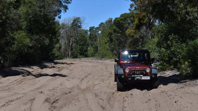
The access track from here is sand and 4WD is required. The sand can be soft, especially if there hasn’t been any rain for a while and the sand is dry. If you have let the pressure down in your tyres, most 4wd vehicles won’t have any troubles.
The track is about 2km with a gate just before entering the beach itself. Going onto the beach is usually easy, just be careful if you are one of the first after a high tide as a ledge of sand can be created when the beach erodes. Returning to get back off the beach is where many have troubles and get stuck, however, this isn’t that difficult if you have prepared properly.
If the tide is high you will likely have to stay high on the beach in soft sand. You will be grateful you have let your tyres down in this case and so will your vehicle as it won’t have to work so hard to keep moving.
During low tide, the lower part of the beach is smoother and firmer. You will be able to drive with less effort and a higher speed, however, keep an eye on your speed because the speed limit is 30 when you first get on the beach and doesn’t increase much until you are passed the popular lagoon areas.
Rangers and police can often be found, especially during popular warm weather weekend and public holiday days. Speed guns are used so keep an eye on the speedo, at 30km it is easy to creep beyond the speed limit. The 30km speed limit also applies to the inland tracks.
Keep an eye out for wedge-tail eagles while you are driving up the beach. We saw a dozen or more as they were flying over the brush behind the dunes looking for food. One travelled along beside us about 20 metres away for 5 minutes as we drove up the beach.
Bribie Island Lagoons
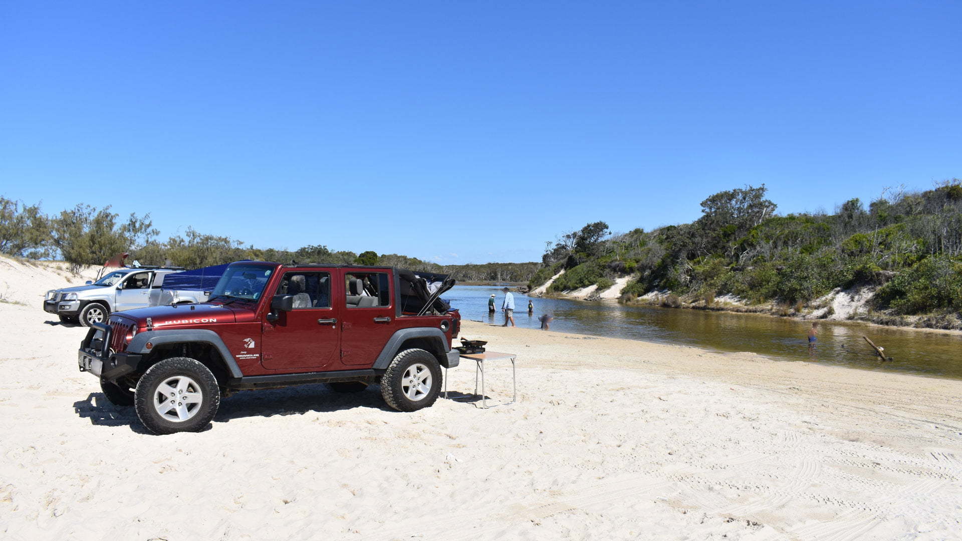
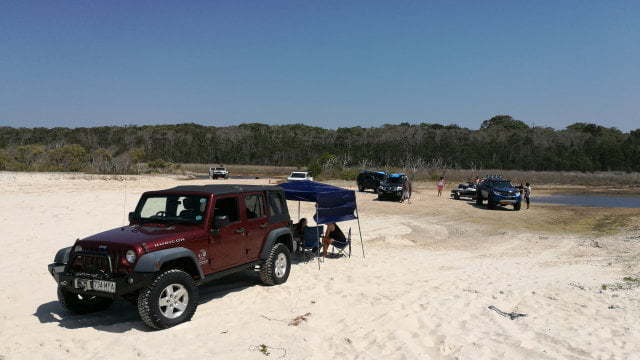
A spot can be found along the beach just about anywhere to stop and set up a spot to enjoy it from. My favourite spots to stop are the lagoons that sit just behind the vegetation behind the beach.
There are four lagoons, called first lagoon, second lagoon, third lagoon, and I’m sure you have already guessed, forth lagoon. There are proper names for them too, The first lagoon I haven’t been to before just after entering the beach from the access track. I had thought the first lagoon may have been back along the beach but looking at Google maps satellite it is north close to where the access track comes out.
The second lagoon and third lagoon are the better ones, and as a result, these are the most crowded. To get a position next to the lagoon water during the weekend or public holiday, it is best to be there early.
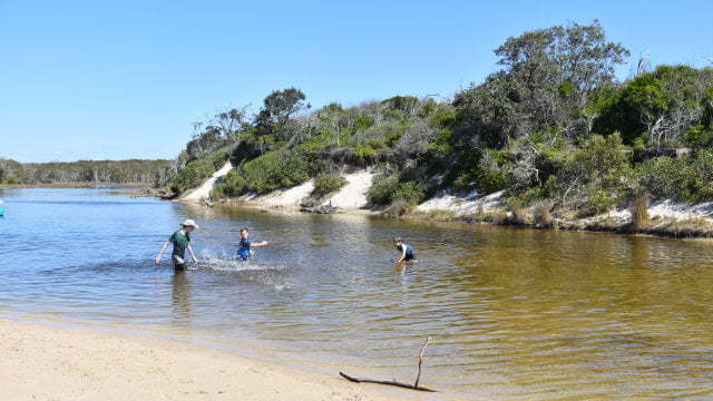
The Second Lagoon, also known as Norfolk Lagoon, has the most waterfront on the lagoon, and the lagoon heads in both directions (north and south). The water is not too deep, great for the kids to play safely while you cook up some lunch.
The lagoon water is brackish and stained brown from the tannins in the vegetation falling into it (leave litter and such). The water is mainly fed by fresh rainwater but is topped up from the ocean during big high tides, making it salty but not as salty as the ocean water.
The lagoon continues for a while behind the bush. If you have a kayak, it is a great place to explore the lagoon waters further in.
Norfolk Lagoon occasionally breaks the sand to create a constantly flowing stream across the beach. Crossing the stream can be dangerous, depending on how deep it is, so check how deep it is before attempting to drive across. I don’t know how often this occurs, every time I have been to Bribie Island there is no water flowing across the beach.
The Third Lagoon is called Mermaid Lagoon. It isn’t a large as Second Lagoon and the water heads in one direction. Otherwise, it is similar with water deep enough to have a swim but shallow enough for the kids to play. The water is the same brackish and brown water.
Depending on the level of the water there is often some space behind the southern sand dune offering some shelter from the wind. Handy to keep the sand from blowing on your sausages but it can also reduce the cool breeze coming off the ocean, something that is appreciated during the hotter months.
The Third Lagoon is another great spot to launch a kayak. There isn’t as much lagoon at the beach to set up at, but head around the corner and you will find the water continues north and south about 0.5km each way to explore.
Fourth Lagoon is called Welsby Lagoon. It is the quietest of the lagoons with only a small area near the water. The water is shallow for the most part and during long dry weather, Welsby Lagoon can dry up or at least leave it so shallow the water isn’t so great to have a swim.
On busy days and the weather has provided enough rain to keep the lagoons topped up, the Forth Lagoon can be a good backup spot.
Ocean Camping
Beyond the Forth Lagoon, the beach heads to the camping areas and the northern access track. The Ocean Beach camping area starts when the speed limit drops from 50 to 30, and continue up to the day use area at the entrance of the Northern access track.
The camping areas are lettered (camp area A, camp area B, etc up to camp area V). Some areas have a single camping side, others have two or more with a total of 64 campsites. All of the campsites are tucked into the dunes with an access track to get to them. There is no need to drive over the dunes themselves.
Most of the campsites do not have any facilities. Camp area ‘P’ (campsites 37 to 53) have toilets, showers, and a portable toilet dumping spot.
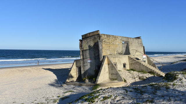
Bribie Island Fort and Day Use Area
After the ocean beach campsites, the Northern Access Track is reached. The day use area is fairly small, and really not somewhere to stop for lunch. There are no picnic tables and only limited parking space. However, there are toilets and as they are the only toilets on the ocean beach site they are often appreciated for a quick break. An open-air shower, with modesty walls, can wash off the salt water after a swim.
Back onto the beach, continue north and the World War II fortifications are reached, starting with the southern searchlight. A searchlight at each end of the fort lit up targets in the night for gunners to take aim. The southern light supported the Number One Gun at ready 24 hours a day, and the northern light supported Number Two Gun on standby 24 hours a day.
The gun fort bunkers held 6-inch Mk XI guns weighing 35.6 ton, recycled from WWI ships. The guns and the massive logs supporting the roof were lifted into position by hand, without access to cranes.
The guns shot 46.5km projectiles stored in bunkers beneath the fort, keeping the highly explosive cordite behind a steel door away from the flash of the gun. The door frames were copper lined to avoid sparks.
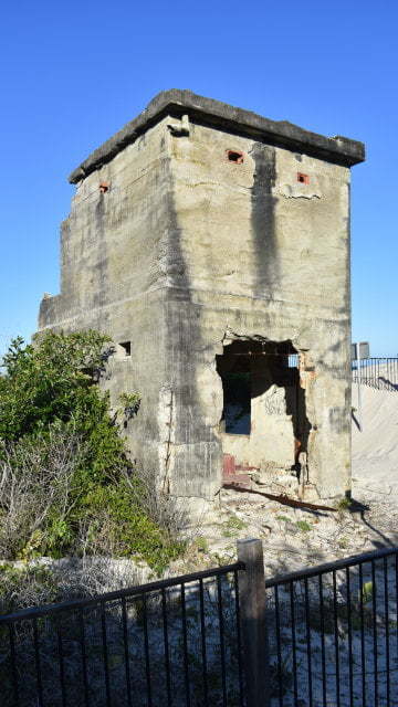
The daily roster board can still be seen in one of the bunker rooms. It is too deteriorated to read it properly, and the graffiti doesn’t make it any easier.
The fort buildings have deteriorated a lot. In addition to normal weathering, the sand underneath has been undermined so they are in various degrees of lop-sidedness.
The northmost bunker sits in the middle of the beach. It marks the limit for driving on the beach, to protect the narrow northern spit of Bribie Island. From here you can walk the last 5km to the northern tip of the island, finishing opposite Caloundra in the Sunshine Coast.
Northern Access Track
The return trip can either be back along the beach near Woorim or take the Northern Access Track on the inland side of the island. Using the northern access track during high tide provides an alternative to the more challenging soft sand on the upper part of the beach.
Heading passed the day use area, the track heads inland of the island. A kilometre in, there is a track leading to the foundations of an old lighthouse. The track is blocked for vehicle access, but it is only a 70m walk. The lighthouse was the second lighthouse, built in 1987. The first was build in the late 1800s and operated until 1952.
There isn’t much to look at other than the foundation. I’ve driven passed it so many times before and found out after this trip that the lighthouse was removed and scrapped a few months before in June 2018. It was removed because of concerns of erosion undermining the foundations creating a dangerous situation.
Continuing another kilometre leads to Lighthouse Reach, coming to the western side of the island and Pumicestone Passage. Lighthouse Reach is an inland day use area, with picnic tables and a wood BBQ.
The track then heads back into the middle of Bribie Island, going through the scrub and forest plantations. In the plantations, the track heads towards the west again and enters a water marsh area. It sits on an elevated and narrow sand track.
It is amply wide enough for a vehicle to drive on without concern, however, passing another vehicle is another story. There are wider spots where you can pull over to allow vehicles to pass (or you pass them), but care and courtesy is needed for this part. It isn’t uncommon to find someone who has gone too close to the edge of the raised sand track to pass another vehicle and slid too far down the side. This section is a little over 1km before entering another plantation section and heading south again.
There are a few spots where the sand becomes deep and soft. I’ve assisted in recovering a few vehicles bogged in the sand travelling by themselves. Usually, it is a simple task of letting some air out of their tyres and away they go. A couple of times a recovery using a snatch strap has been needed to get them moving again.
With the most difficult section finished, the track arrives at the intersection leading to Poverty Creek Campground and day use area, an 8km detour. The camping area is quite large. There are 11 campsites for tent beside the car style camping, and a larger open area with unmarked campsites. A toilet block is near the entrance of the designated campsites.
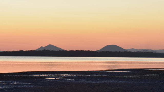
Go passed the campsites to the day use area on the banks of Bribie Island on Pumicestone Passage, with scattered picnic tables. The Glasshouse Mountains ![]()
![]() can be seen across the passage, a beautiful background for the sunset over the water.
can be seen across the passage, a beautiful background for the sunset over the water.
Continuing south on the Northern Access Track 5.5km from the intersection to Poverty Creek brings you to the White Patch entrance of Bribie Island National Park, with another campsite just before to Gallagher Point Camping Area.
To Get There
From the Bribie Island Visitor Information Centre, head west towards Woorim (the exit nearest to the centre) to the roundabout. At the roundabout, take the third exit for Goodwin Dr towards Woorim. A sign before the roundabout shows a brown sign for Surf Beach for the third exit. Continue for another 6.3km, heading straight through a number of roundabouts, arriving at the shops of Woorim. The road bends to the left, continue for another 1.3km with the entrance to the Ocean Beach Access Track on the right.
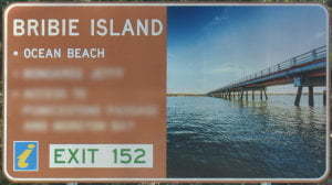
On the Bruce Hwy north of Brisbane, take the exit to Bribie Island (exit 152). If heading north, after taking the exit, continue straight ahead under the overpass then immediately left to head to Bribie Island. If heading south, after taking the exit, continue straight ahead under the overpass. The exit follows along the highway for about 1km. Keep to the left to head to Bribie Island. Follow along Bribie Island Rd for 18km to the bridge across to Bribie Island. Continue over the bridge and at the roundabout head straight across (third exit) towards Woorim. After 600m at the next roundabout, take the third exit for Goodwin Dr towards Woorim. A sign before the roundabout shows a brown sign for Surf Beach for the third exit. Continue for another 6.3km, heading straight through a number of roundabouts, arriving at the shops of Woorim. The road bends to the left, continue for another 1.3km with the entrance to the Ocean Beach Access Track on the right.
Links
https://parks.des.qld.gov.au/parks/bribie-island/pdf/bribie-isl-rec-area.pdf
https://parks.des.qld.gov.au/parks/bribie-island/pdf/bribie-oceanbeach.pdf

