


The brown sign destination Purling Brook Falls Lookout is a highlight at Springbrook. It is accessible from the Gwongorella Picnic Area ![]()
![]() , or from The Settlement Day Use Area. The brown signs lead you to Gwongorella Picnic Area.
, or from The Settlement Day Use Area. The brown signs lead you to Gwongorella Picnic Area.
I was at Gwongorella Picnic Area the afternoon before, and had a quick look at the falls, but wanted to spend more time walking the Purling Brook Falls trail. I camped at The Settlement Camp Grounds nearby and started my walk from The Settlement Day Use Area early in the morning.
The walk from The Settlement joins with the Purling Brook Falls circuit at the top of the Purling Brook Falls on the eastern side. Along the way is an old hut where water was pumped to homesteads in the area, and the Carricks Creek is crossed along the way over a memorial bridge for George Haddock, in recognition to his contributions to Queensland National Parks.
 From the eastern side of the brook, continuing ahead a short way leads to the eastern lookout of the falls. This lookout is closer to the falls than the western lookout and looks directly over the Purling Brook Falls circuit trail at the base of the falls. Looking down gives you an appreciation of how far down the walk takes you (and hopefully doesn’t put you off from taking the walk).
Back at the head of Purling Brook before the falls, cross over to the western side. The crossing is at the junction of Carricks Creek and Purling Brook. Carricks Creek was showing a tumbling flow of water over small rock shelves, and in contrast, Purling Brook had still water to the edge of the walkway before starting its descent towards the falls.
Continuing the walk around, it joins the path from Gwongorella Picnic Area ![]()
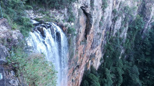
![]() , and down to the western lookout. The western lookout of Purling Falls is further along the canyon than the eastern lookout, providing a better angle looking back towards the falls.
, and down to the western lookout. The western lookout of Purling Falls is further along the canyon than the eastern lookout, providing a better angle looking back towards the falls.
From the western lookout of Purling Brook Falls, you can either head back, or continue on to walk the Purling Brook Falls circuit. The walking to this point is not too arduous, and only a few odd steps. Continuing on remains fairly flat for a while until eventually reaching the beginning of 450 steps to get down to the lower levels of the canyon.
The walk first leads away from the falls. The top of the Tanninaba Falls is along the way, crossing over Kuralboo Creek. It is a nice spot to have a quick stop for some photos, but there is no way to view the falls themselves (not from here).
Glimpses of views down the valley are provided, as the trail continues to lead further away from Purling Brook Falls, then the stairs are reached and the descent begins. There are many steps, and when there are no steps it frequently continues downwards. The trail winds back and forth a few times before head back towards Purling Falls.
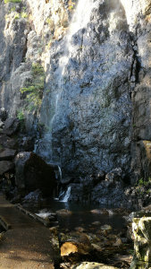 The trail then approaches the base of Tanninaba Falls, cascading down along the face of the cliffs (Tanninaba is an Aboriginal word meaning Zamia Palm ground). At the bottom, the trail leads through large boulders fallen from the cliffs above, after crossing over a small raised wooden bridge over Kuralboo Creek (Kuralboo is Aboriginal for deep down). I have read that these falls are sometimes heard but not seen, as the water flows between the cracks in the cliffs, so it was nice to be there when there was enough water to see the waterfall.
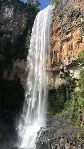
Eventually, the trail reaches the junction to head to Warringa Pools (Warringa is Aboriginal for cool place), before walking down to the base of the Purling Falls. It was around 7.30am, about an hour after starting the walk from The Settlement, and the sun hadn’t yet reached into the canyon. The paths were very wet and muddy, with an almost constant spray of water coming from the falls.
I continued on a little further to a suspension bridge that crossed over to the eastern side of the Purling Brook Falls circuit. At the other side of the bridge, the track is closed due to damage caused from ex-tropical cyclone Debbie that caused fallen trees, landslides, and other hazards. The circuit is closed from the bridge through to where it comes out near the eastern lookout at the top of the falls. It isn’t known when this section will reopen, with an update to be provided mid-2018. See the National Parks alert ![]()
![]() for current information.
for current information.
The sun was only just starting to shine on the western rock cliffs, so I headed to Warringa Pool while waiting for the sun. The walk to Warringa Pool is comparatively easy to the walk down to the falls, but it does have a few more obstacles on the ground to negotiate, including some muddy sections.
Warringa Pool is a beautiful swimming hole, which is allowed, unlike the waterhole at the base of Purling Brook Falls. A large rock ledge that is mostly dry lets you walk above the waterhole. Climb down the rocks provides access to the waterhole below, or stay above and enjoy the quiet waters before it flows over the rock ledge.
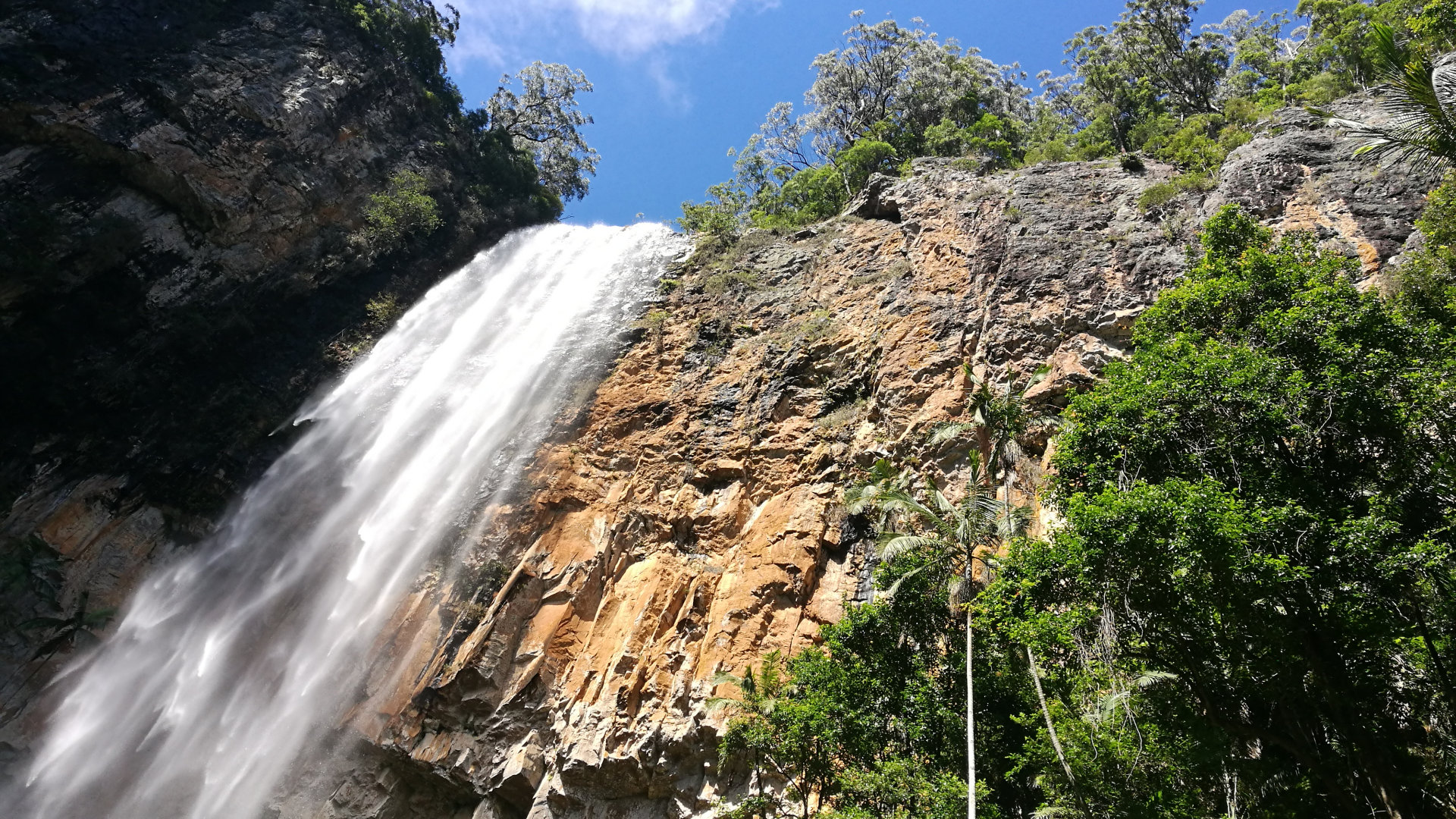
Returning to the base of Purling Brook Falls, the sun had started enter the canyon. There were a lot more people coming through as well, breaking the false illusion the earlier hours provided for a quiet place you can enjoy to yourself.
 Waiting for the sun to come across the falls was worth the wait, as it brought the colours of the canyon walls to life, and highlighted the water falling from the cliffs above. The resulting spray mist drifts across the green tropical plants clinging to the steep ground.
This officially made Purling Brook Falls my favourite brown sign destination in Springbrook, and justified camping overnight to have more time to enjoy this beautiful area. All up it took about 4 hours, including the extra walk to Warringa Pool. There was probably a good hour or more waiting for the sun, so the walk can be done quicker.
The walk from The Settlement Day Use Area is also the start of the Gold Coast Hinterland Great Walk, a 54km walk that goes through to O’Reilly’s, and passes through Apple Tree Park ![]()
![]() , another brown sign destination in Springbrook. The great walk follows the Purling Brook Falls circuit, and up to Warringa Pool, then continuing onward from there.
, another brown sign destination in Springbrook. The great walk follows the Purling Brook Falls circuit, and up to Warringa Pool, then continuing onward from there.
To get there:
 From the Springbrook Mountain Visitor Centre, continue south on Springbrook Rd for 4.2km, and turn left into Forestry Rd. Gwongorella Picnic Area with parking for Purling Brook Falls Lookout is 400m straight ahead at the end of Forestry Rd.
