

Lions Road was constructed by the Kyogle and Beaudesert Lions clubs after it was rejected by the NSW government to provide a link between Kyogle and Rathdowney.
The Lions Road starts from Summerland Way between Woodenbong and Kyogle, continuing on from Gladys Creek Road.
Gladys Creek Road follows along Gladys Creek into the valley before reaching Lions Road itself. Lions Road begins to climb the McPherson Range and enters the Border Ranges National Park.
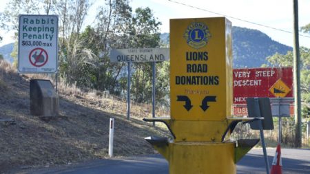
The climb finishes at the Queensland border with a donation box where a gold coin donation is requested. Vehicles often stop here to get photos at the border.
A couple of kilometres before the border is the Border Loop Lookout which offers views from the McPherson Range back towards the valley you have come from.
The end of Lions Road is a short way across the border where the road becomes Running Creek Road heading to Rathdowney and on to Brisbane as the brown sign suggests.
To get there
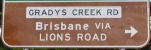
From Kyogle, head north along Summerland Way for about 18.5km, passing through Wiangaree, and turn right into Gradys Creek Road with the brown sign for “Brisbane via Lions Road”.
From Woodenbong, head east on Mount Lindesay Rd towards Brisbane and Kyogle and after 3.9km turn right into Summerland Way towards Kyogle. Follow Summerland Way for 35.9km and turn left into
From Rathdowney, see Lions Road Scenic Drive ![]()
![]() for directions
for directions

