


Mulligans is an area in the Gibraltar Range National Park named after William Mulligan who proposed a hydroelectric scheme for the area. Mulligans Hut is one of two huts William Mulligan built, the area is referred to as Mulligans Campground or Mulligans Hut Campground.
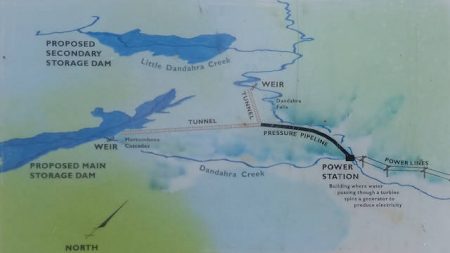
William Mulligan was born of a local grazing family in 1862 and became a prominent citizen and mining engineer. Devoting his vision to local development projects, William proposed a hydroelectric scheme with two storage dams on the Dandahra Creek.
The two dams were to send water over an escarpment to a hydroelectric power station. In the 1920s, two concrete weirs were built to measure the water flow. Both of the weirs can be seen today on walks from Mulligans Campground.
William Mulligan partnered with George Cumberland to reopen a copper mine ![]()
![]() in the foothills below the proposed construction of the Dandahra hydro-electric scheme at Cangai (pronounced Cang-ghee). The partners approached the Minister for Mines for a loan in 1942, however, the capital and equipment were not available in the war years. The geologists and an independent engineer were not optimistic about the project. When the leases expired in 1952, the Dandahra Hydroelectric Scheme was not built.
in the foothills below the proposed construction of the Dandahra hydro-electric scheme at Cangai (pronounced Cang-ghee). The partners approached the Minister for Mines for a loan in 1942, however, the capital and equipment were not available in the war years. The geologists and an independent engineer were not optimistic about the project. When the leases expired in 1952, the Dandahra Hydroelectric Scheme was not built.
A newspaper article talks about William Mulligan as a pioneer of hydro-power ![]()
![]() and his attempts to harness the power of water over several projects.
and his attempts to harness the power of water over several projects.
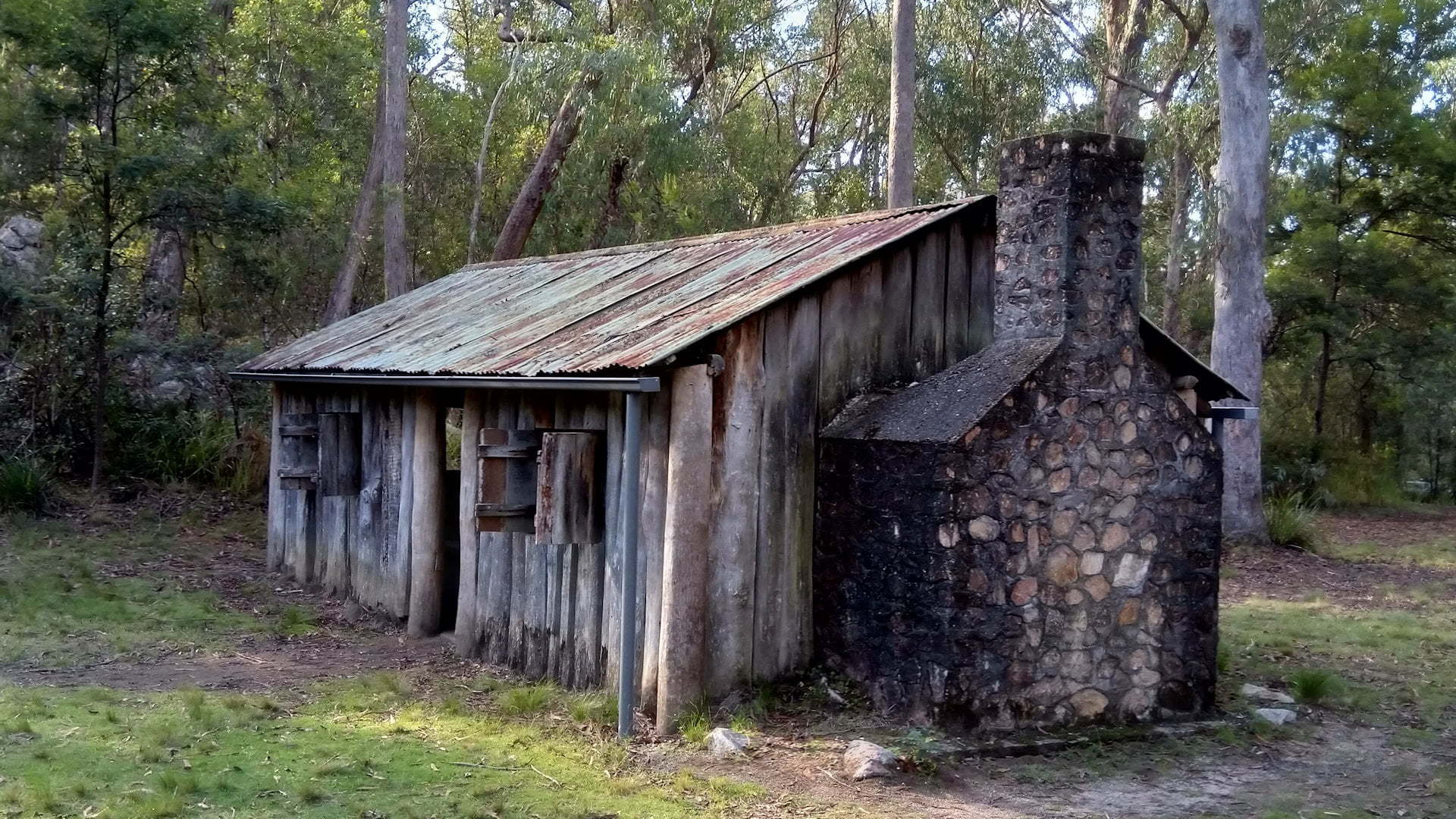
The hut seen today is the larger of the two huts, built by William Mulligan, a slab-walled hut with a dirt floor and originally had a bark roof. The hut seen today was rebuilt in 1968 by the National Parks and Wildlife Service after it was damaged in a fire in the 1960s. The smaller hut was destroyed by the fire.
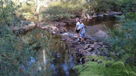
The hut is a short walk from the day use area at Mulligans. There is plenty of open grass space for kids to use up some energy. Our boys were kicking a soccer ball around when they were not exploring the hut and creek. The banks of the Little Dandahra Creek runs along the length of the grass area with a narrow border of vegetation.
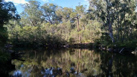
The creek beside Mulligans Hut has a calm body of water leading to a small weir of stones. We found a log protruding out to the water and took turns to sit on the end and take in the calm and peaceful tranquillity.
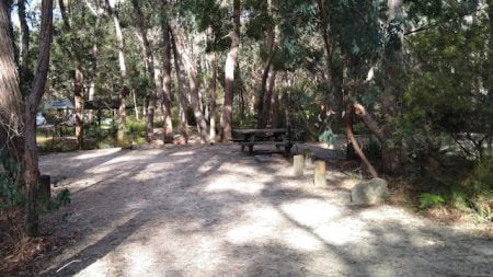
The day use area has more space and toilets next to the parking area. Free BBQ at a sheltered picnic table area with a view across the bush from the BBQ is a wonderful spot to make a hot lunch.
The camping area runs adjacent to the day-use area, with a separate entrance to the loop track around the camp sites. The camp sites vary in size and shape, some are suitable for a camper trailer or small caravan.
There are no bookings so you take a chance on available spots. Boundary Falls Campground ![]()
![]() is a good alternative with more open camping sites, although there are no bookings there either and less convenient if you want to do the walks around Mulligans Hut.
is a good alternative with more open camping sites, although there are no bookings there either and less convenient if you want to do the walks around Mulligans Hut.
The Mulligans Campgrounds campsites include a picnic table and fireplace with a swing-away. A supply of firewood is at the campgrounds to use with the fireplaces, which is a great benefit considering firewood cannot be collected in national parks. There is no guarantee there will be firewood, so it may be a good idea to bring your own as a backup, just in case.
Walking Tracks at Mulligans Hut Campground
Mulligans Hut Campground is a great spot as a base for many of the walks in Gibraltar Range National Park, some accessible directly from the campgrounds.
Barra Nulla Cascades
Barra Nulla Cascades is a short easy walk from Mulligan’s Hut. This walk is easy, only 15 to 20 minutes, so if you don’t want to walk too far, this is the one to do. The cascades have formed popular swimming holes including a waist-deep plunge pool surrounded by giant boulders. Take care of the current of the water and submerged boulders.
Dandahra Falls
The Dandahra Falls walk starts at Mulligan’s Hut, passing the beautiful Barra Nulla Cascades. Walk through dry forest and rainforest, descending 250 metres for a view from beside Dandahra Falls. The falls are the highest in Gibraltar Range National Park. The Dandahra Falls walk starts easy, sharing the start of the Murrumbooee Cascades walk. The walk becomes a difficult track, allow for 3 hours for the 4.5km return walk.
Murrumbooee Cascades
The Murrumbooee Cascades walk starts at Mulligan’s Hut, sharing the same start to the Dandahra Falls walk. Walk through forests to a creek junction that narrows to form the Murrumbooee Cascades before the creek plunges over the edge of the escarpment. The easy 6km return walk takes around 2.5 hours. The Murrumbooee Cascades shows one of two concrete weirs built in the 1920s by William Mulligan.
Tree Fern Forest
The Tree Fern Forest walk starts at Mulligan’s Hut, sharing the start of The Needles walk. It descends into the rainforest and comes out into a high wet forest of Sydney Blue Gums and tree ferns. There are four different types of tree fern to see along the track. The walk is a medium grade, taking about 3 hours for the 8km return walk.
The Needles
The Needles walk takes you to view six granite columns that rise 80 metres above the edge of the escarpment, overlooking the Dandahra Gorge. The track starts crossing Little Dandahra Creek and the historic weir build by William Mulligan. The walk leads through dry forest and changes to rainforest as the track climbs higher.
Little Dandahra Creek Walk
Little Dandahra Creek walking track goes passed granite outcrops, through montane heathlands, and alongside the Little Dandahra Creek. There are natural pools to take a cool break in and admire the rocky landscape of the Gibraltar Range National Park. The 13km return walk to Platypus Picnic Area is a medium grade walk, taking around 4 hours. Little Dandahra Creek walk is also part of the Gibraltar-Washpool World Heritage walk.
To Get There
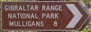
From Glen Innes, from the New England Hwy, turn into Gwydir Hwy towards Grafton. Follow Gwydir Hwy for 68.4km. The entrance to Mulligans is on the right. Follow along the dirt road for about 9.5km to reach the Mulligans Hut Campgrounds and day-use area.
From Grafton, head west towards Glen Innes on Gwydir Hwy. Follow Gwydir Hwy for 85.6km. The entrance to Mulligans is on the left. Follow along the dirt road for about 9.5km to reach the Mulligans Hut Campgrounds and day-use area.
From Boundary Falls, head back out to Gwydir Hwy and turn left. The entrance to Mulligans is 8.5km on the right.
From Raspberry Lookout, head back out to Gwydir Hwy and turn right. The entrance to Mulligans is 7.9km on the right.
